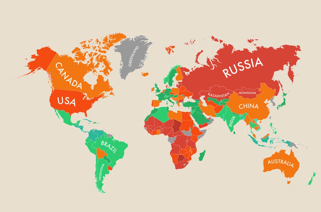
Did you know that our picture of the world is distorted? After seeing these photos, you will never look at the world the same again! The reason why some countries on the map are larger or smaller than others, even though they are not, is the antediluvian transverse Mercator projection or. a cylindrical map projection in which meridians and parallels are straight lines that intersect at right angles, and which allowed mariners to plot their course as straight lines. The result of transferring the surface of the Earth to paper is today's misconception of the size of some parts of the world. The projection of the three-dimensional world on paper has its price, and we pay it with a distorted picture of the world even today, even though the maritime industry no longer uses classic maps for navigation. That is why such cards are still hanging in schools and, among other things, falsely create the impression that Russia and the USA are so big.
map
It's amazing how we go to foreign places, see tourist locations, natural and cultural attractions, happily take photos, and return home with the same shots as thousands of other tourists, with the same photos that we find tons of on Google. We all photograph the same scenes, from the same place (herd instinct?), which is precisely why they lose their originality, because someone else could easily have taken it and you wouldn't even notice it. Philip Schmitt's Camera Restrict therefore prevents you from taking the same shots as everyone else.
For April 1st, Google has taken Google Maps and turned it into a Pack-Man arcade game. The streets have thus turned into a labyrinth, and the game of our youth can be played on our doorstep (the advantage of the "home playground") or in a location of our own choice. Blinky, Pinky, Inky and Clyde can also be avoided on the Champs-Élysées or in Times Square, and everything is accompanied by the famous musical background.
The Google Earth service allows us to fly anywhere on Earth. But that doesn't mean we can see everything. In the extensive collection of satellite images, for one reason or another, there are gray spots, places that Google refuses to show us. That's why he censors her one way or another. Check which ones.
The disposable monthly income of the population is a figure we like to play around with, but we actually don't know much about the situation around the world. Of course, we know those close to us with whom we like to compare ourselves, especially those who are high above us, but in between there are a bunch of countries that may surprise you with their numbers. If you are interested in how much people around the world earn on average in their country, dive into the infographic of the American portal Movehub. And where is Slovenia?!
Every day we are bombarded with numerous statistics and research results, but we often only grasp the full extent of things when they are presented to us more plastically. With maps, such as we did not meet in geography lessons or geography, spreadsheets and infographics, which illuminate in a unique way what dry statistics tell us, but also hide. We've collected just such, so prepare to be surprised, if not shocked.
You won't get the most accurate map of the universe at a gas station or tourist office, and you won't be able to unfold it on the dashboard of your car either. But the screen will be big enough for you to be able to see the result of a study for the scientific journal Nature, where scientists, while mapping the galaxies close to us, discovered that the Milky Way is part of a huge celestial structure of 100 thousand galaxies called Laniakea or "the vast sky". .
Do you believe that with this fascinating infographic of the world map of happiness, prepared by HPI, it has been proven that you can live a fuller and happier life only outside of Europe? See which countries give their residents the best conditions for happiness or, in short, where in the world people are the happiest.
Google Street View can hide from this view. I don't know where, because Uncle Google has covered almost every corner of the world with his car, but since he doesn't have an airplane exam, certain things are still not covered. And this is where TravelByDrone has now stepped in, a map that gives a new dimension to the beauty of the world with drone footage.
While we are used to digital guides, GPS devices, directing us along the shortest, most optimal and fastest routes, Yahoo researchers have recently expanded their perception of maps, so that they can now also take us along the "most beautiful", "calm" and "lively" routes. The technology is currently limited to walking, but it won't be long before other forms of transport will adopt it.
A few years ago, packing was limited to a suitcase, but today you have to 'pack' things into your smartphone as well. The world offers a thousand and one interesting things and the web is not far behind, so take a look at 6 apps that will raise your travel experience to the highest possible level. The best travel apps of 2014!
You will probably rarely get the answer "geography" when asked the question "What was (was) your favorite subject at school?". But if at school we were shown the maps that you will see below and not just the ones from the atlas and the textbook, this could well change. All of you who are no longer peeling school desks can clearly make up for the 'missed material' now.